By Gu Yekai, People’s Daily
A program for promoting the application of China’s BeiDou Navigation Satellite System (BDS) in the transportation sector initiated by Chinese enterprises was recently launched. The program will bring innovative BDS applications, which are currently piloted in eight Chinese cities, to the rest of the country.
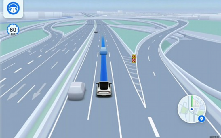
The innovative BDS applications of the program, including lane-level navigation and real-time traffic lights countdown, are high-precision BDS services. They will promote the commercialization of the BDS in the transportation and travel industries.
The BDS has entered a new phase of development that features higher precision, higher reliability and better services.
According to statistics, the total output value of China’s satellite navigation and location-based service industry has reached 470 billion yuan (about $68.3 billion).
As of January this year, over 1.5 billion intelligent devices around the world had been connected to BDS temporal and spatial services, and the high-precision services were used over 170 billion times monthly in some 230 countries and regions. BDS-based positioning was activated more than 300 billion times in AMAP, a Chinese map app, on a daily bases.
The BDS is constantly expanding its application in various sectors. Its temporal and spatial services, as usual as water, power, gas supply and other public services, are fully integrated into infrastructure construction and energizing all walks of life, including transportation, agriculture, forestry, husbandry and fishing, smart port construction and power inspection.
By the first half of 2022, the BDS has been applied in some 20 industries and sectors, with more than 15.5 million Beidou-based products widely used.
“Today, the BDS has become an important temporal and spatial infrastructure of China and is forcefully supporting the country’s digital economy,” said Yu Xiancheng, head of the GNSS&LBS Association of China. The increasing industrial and civil scenarios have effectively promoted the BDS application, Yu added.
As the BDS is integrated with AI, big data, cloud computing, 5G communication and other frontier technologies, its application is also gradually extended to emerging industries.
Lane-level navigation is a typical application of intelligent temporal and spatial services, as well as a product of in-depth integration between the BDS and emerging technologies.

“With lane-level navigation, users can obtain extremely high-precision positioning on mobile applications while driving. When they need to change lanes, for instance, to an interchange or a ramp, lane-level navigation would provide more accurate guidance,” said Liu Zhenfei, president of AMAP.
The effective application of lane-level navigation couldn’t have been possible without the all-around update of technical elements such as positioning antennas, positioning algorithms, positioning chips and mobile map apps.
Since 2019, Chinese enterprises have joined hands to tackle software and hardware bottlenecks, making a series of breakthroughs in lowering the energy consumption of positioning antennas, promoting real-time dynamic measurement, and adapting chips from mainstream manufacturers.
Yang Changfeng, chief designer of the BDS and academician of the Chinese Academy of Engineering, noted that the BDS in the new era seeks development through application and further promotes application in development.
According to him, China will expand new industries of the BDS and strive for innovative and integrated development of various industries, so as to take the lead in the world in building a whole industrial chain in high-precision mobile positioning.
At present, the application of the BDS is in a critical period, which creates abundant opportunities for the development of the industry.

According to a 2022 white paper on Chinese satellite navigation and positioning services, the core industrial output value of industries directly related to the R&D and application of satellite navigation technology, including chips, devices and algorithms, hit 145.4 billion yuan in 2021. The output value driven by satellite navigation applications and services reached 323.6 billion yuan in the same period.
There were about 14,000 enterprises and organizations engaged in China’s satellite navigation and location-based service industry, with over 500,000 employees.
Over recent years, the BDS industry has benefited a batch of enterprises, and these enterprises have also created considerable economic benefits for local communities.
Promoting the development of the BDS and location-based service industry is an important measure for China to accelerate economic digitalization and empower the digital economy, said Yu.
During the 14th Five-Year Plan period, or between 2021 and 2025, the country will keep promoting the standardization and popularization of the BDS, give full play to the temporal and spatial services and achieve large-scale and market-oriented development of the system.


